
Established as The Skamokawa Eagle in 1891
Established as The Skamokawa Eagle in 1891
News of Western Wahkiakum County and Naselle
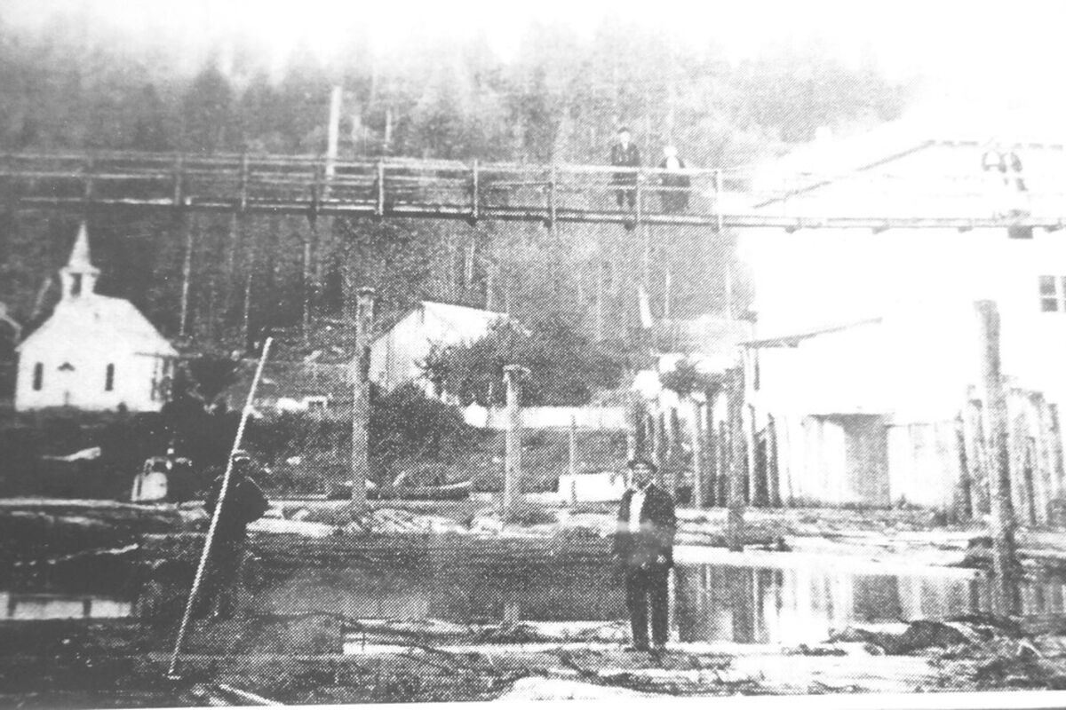
Grays River's Meserve Store and Swinging Bridge in 1915. Courtesy of Appelo Archives.
It's almost August. How did that happen? It means the Fair, the Loggers Reunion and Labor Day weekend are all just around the bend. The older I get, the faster the days go by. There is a song that talks about now that we're older, how many more times will we see the cherry blossoms in bloom? We have time left and no real idea of how long that will be, but our time needs to be used so that we spend it with family, babies, young ones in pre-school, friends and elders, and yes, cherry trees. May God grant us many more days and years full of family and joy.
Last Sunday's fire in Oregon was a good reminder that we should watch for smoke wherever we are. We are the forest fire monitors ourselves, so be watching.
Last week I shared some of Lenore Sorenson's memories of the Covered Bridge. She mentioned that "before the Covered Bridge was built there was a "swinging bridge" originally built by H.P. Ahlberg prior to 1900 to span Grays River adjacent to the present site of the Bridge." I found a photo in some Meserve family files at the Archive Center and am hoping to take a photo of it that will work for The Eagle. In it I hope you can see the store to the right (remember it's on pilings and two stories high). A paragraph on the back gives this information about the photo and swinging bridge: "The swinging bridge was located upstream from the Meserve store at the corner of Loop Road and SR 4. Mr. and Mrs. Thad Barr are standing near the center of the swinging bridge that was originally used for the Ahlberg farm before the Grays River Covered Bridge was built. It was moved to this location near the Grays River Hotel, located across the road from the Meserve Store built in 1907 to replace the Samuel Walker store building at the same location that was purchased earlier, circa 1899. The swinging bridge was moved here circa 1906 after the Covered Bridge was constructed at the Ahlberg Farm.
Not shown in this photo, a railroad bridge was also built near the cable bridge (upstream) to permit H.B.A. Logging Company to use the "railway" on the Frank A. Durrah place to dump their logs into Grays River. A railroad grade ran across the "Smith Place" (presently owned by Clinton Smith) and the Peterson farm, now owned by Don Crouch. This cable bridge was moved to connect the Frank Badger farm (Joel Fitts farm today) with the Clarence Worrell (Antone Sorenson) farm. This move was made circa 1920.
In the photo, the boom men are rafting cedar logs in front of the Grays River Methodist Church (on the left) which had been moved to this location in 1914 due to the new road running through Grays River and on to the west, that needed more room. The church was previously located near Luke Kimbel's farm (directly upstream from the present George Gudmundsen farm). The logs may have been destined for the Johnson & Swanson Shingle Mill in Rosburg near the Sidney Larson residence."
There are names you may not recognize in this information, but remember people traveled by boat and there weren't many roads in the early 1900's, let alone roads named, so folks recognized locations by families' names who owned the land. Remembering that the Bonneville Dam was built in 1938 may help you realize the early "behavior" of the Columbia River, thus the higher water in Grays River. Before the Dam was built the Columbia had a stronger current coming in and out of Grays River at the corner where Meserve Park is now. There was little silt in the Grays because the tugs and rafts cleaned out the bottom of the river, and at high tide had the capacity to move rafted logs along out to the mouth of the Grays on into Grays Bay. Tugs and boats came up the Grays, clearing out the silt,, then the tugs hooked on to small log rafts at the corner near the church and pulled the rafts on out to Grays Bay to be added to the larger rafts gathered in the Bay, or to Astoria or even to the local cedar shake mill that was located at the end of Mill Road off Altoona Pillar Rock Road.
Calendar of Events:
Mondays: First Monday of the month, Naselle Library has a men's coffee gathering 10-11:30.
Tuesdays: Naselle Lutheran Church sponsors morning quilters and knitters in afternoons.
Third Tuesday: Naselle Grays River School Board meets at 6:30 in school library.
Second Wednesday of the month: Grays River Flood Control District meets at the Grays River Fire Hall across from Duffy's Pub at 5:30. Also available by Zoom.
Wednesdays: AA meeting at the Grays River Grange at noon.
Wednesdays at 2 at Naselle Library: August 2: Ice Cream Party and Great Egg Hunt.
First Thursday of the month: Grays River/Rosburg Gardening group meets at Johnson Park at 6.
Thursdays: CAP Senior Lunches are located at Rosburg Hall at noon.
Second Friday of month: Women's Coffee Group at Naselle Library at 10.
Second Saturday of month: Grays River Grange's Farmers Market at the Grange 10-1.
July 29: Nordic Music Concert at Chinook School at 5 with kantele and Celtic harp.
August 12: 4-H Horse Show at County Fairgrounds in Skamokawa.
August 15: Naselle GR Valley School Board meets at 6:30 in the school library.
August 17-19: County Fair.
August 19: Loggers Reunion with BBQ and beer from 2-5 at Appelo Archives Center.
September 13: At this meeting of the Grays River Flood Control District, the Columbia Land Trust will give a presentation on new land acquisitions. Come and ask questions of the Land Trust since many I've spoken to would like to know more.
Word for the Week: Health


Reader Comments(0)